CASE STUDY
PARTNER: TRANSYSTEMS CORPORATION
CLIENT: KANSAS DEPARTMENT OF TRANSPORTATION
PROJECT: PAVEMENT MARKING LENGTHS AND SYMBOL QUANTITIES INVENTORY
APPLICATION: US-400 AND US-69 IN KANSAS
EXTENT: 64 LANE MILES
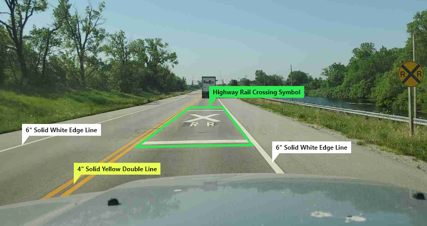
The Kansas Department of Transportation (KDOT) is responsible for road and bridge maintenance, transportation planning, contract compliance, and transportation-related administrative support for the state of Kansas. One of the most important responsibilities of any DOT to ensure the safety and regularity of traffic is the uniform application of pavement markings. Pavement markings provide important information to roadway users such as delineation of driving lanes and direction of travel, lane usage restrictions, safety messages to indicate potentially hazardous conditions ahead, and guidance for many other driving-related tasks.
TranSystems Corporation, a US-based transportation consulting firm, has extensive experience in providing engineering, architectural, planning, and construction solutions to many different clients and transportation agencies. TranSystems was awarded the opportunity to deliver a pavement marking inventory to KDOT, including lineal lengths of pavement markings and quantities of symbol markings. The total length of this project was approximately 32 centerline miles, consisting of three highway and interchange segments located on US Route 400 and US Route 69 in southeastern Kansas.
Most companies that offer transportation asset inventory services typically utilize a labor-intensive process, which involves the manual extraction of assets from roadway images using conventional point-and-click software. This process tends to be inefficient and time-consuming and may also lead to non-systematic errors. On the other hand, iENGINEERING offers a service line of transportation engineering software, known as Transconomy, that automates and accelerates data processing activities for agencies and their consultants to create comprehensive and accurate asset inventories. Using Artificial Intelligence (AI), Transconomy is capable of automatically detecting and classifying traffic signs and pavement markings according to the Federal Highway Administration’s (FHWA) Manual for Uniform Traffic Control Devices (MUTCD), other point assets (such as light posts, utility poles, fire hydrants, etc.), lane markings, line assets (such as guardrails, medians, barriers, etc.), and many more asset types.
To take on this challenge, TranSystems teamed up with iENGINEERING in a joint effort to create a comprehensive pavement marking inventory. The final inventory results were provided in various formats and utilized all the components of the Transconomy ecosystem.

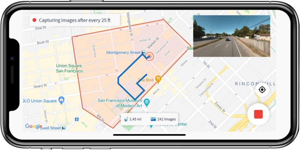
The Transconomy ecosystem consists of Collector, Hub, Manager, and Viewer – each component serving its own function in a comprehensive solution. Transconomy Collector is a mobile application used for roadway image collection. Transconomy Hub provides cloud storage and data processing capability using AI. Transconomy Manager is a web-based platform used for the management of projects and data collection tasks and settings. Transconomy Viewer provides tools to quickly visualize transportation and infrastructure asset data on color-coded interactive maps.
This project was divided into three primary tasks, including right-of-way imagery collection, pavement marking extraction, and inventory delivery. TranSystems opted to use the Transconomy Collector app to collect right-of-way images. Transconomy Manager was used to define data collection areas containing all three road segments of the project. Staff at TranSystems then collected 64 lane miles of roadway image data with simple instructions provided by iENGINEERING to ensure quality and consistency. A smartphone (with the mobile app installed) was mounted to the windshield of a vehicle for data collection. At the end of the data collection, Transconomy Collector automatically synchronized around 3,500 geo-coded images to the cloud (Transconomy Hub) for data processing and asset extraction.
The Transconomy Collector was intuitive and easy to use. Additionally, it provided confidence while in the field that we were collecting the appropriate data and location(s), reducing multiple trips for incomplete data. Syncing was seamless and iENGINEERING was able to quickly confirm data was received. We look forward to working with iENGINEERING on future projects. Chad Banka, PE, PTOE
Once the synchronized images were available in Transconomy Hub, advanced AI algorithms were used to extract linear lengths of pavement markings and quantities of symbol markings to create a comprehensive asset inventory. Enhanced photogrammetry algorithms were also utilized to estimate the GPS coordinates of the extracted symbol markings. As part of this asset extraction process, Transconomy Hub automatically identifies assets that are repeated across multiple images. This ability to identify duplicate assets provides data collectors with more convenience and flexibility in the driving routes selected for a project without sacrificing the accuracy of the inventory results. An in-house QA review was also conducted on the automated inventory results before finalizing the required project deliverables.
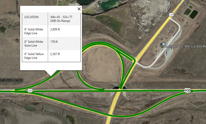
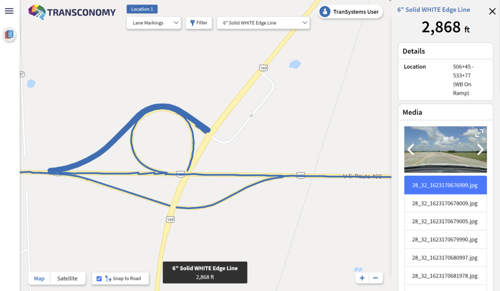
iENGINEERING delivered the processed inventory in comma-separated values (CSV) and Keyhole Markup Language (KML) formats. The key deliverables included lineal lengths of pavement markings, symbol marking quantities, and recapitulation of quantities. As a value-add, iENGINEERING also integrated the inventory results into Transconomy Viewer to provide further insight into the data collected. Within Transconomy Viewer, lane markings are illustrated as lineal segments and symbol markings are displayed as points on an interactive map. In addition to enhanced visualization, Transconomy Viewer provides valuable data attributes and corresponding images for the extracted assets. Advanced filtering options are also provided in this visualization tool, which proved to be very helpful for TranSystems staff when verifying the results.
A common challenge for transportation agencies, now and in the future, is the ability to draw meaningful insights and conclusions from the data collected. Oftentimes, data is collected with no clear plan of action defined thereafter. The Transconomy ecosystem provides a suite of tools and technologies that allows these agencies and clients to fully realize the benefits contained within their data. Also, due to the data-agnostic nature of Transconomy Hub and Viewer, transportation agencies can finally dust off those old hard drives and start extracting assets and insights alike.
Asset management is a recurring need for all transportation agencies and is a necessary consideration to optimize the performance and cost-effectiveness of infrastructure networks. Between the innovative technology solutions tailored to specific client needs and the wealth of experience within the transportation industry, iENGINEERING and TranSystems are well-positioned to continue to grow their relationship and collaborate on many more asset inventory projects in the future.