These days, many pavement management projects are conducted using sophisticated data collection vehicles that use laser systems to develop distress indices. Along with the downward imagery used for pavement, many transportation agencies also acquire right-of-way imagery that shows a forward-looking or 360-degree perspective of the roadway. This right-of-way imagery can be especially useful to “drive the roadway” from your phone or computer and look at features of interest. However, you can use the power of Artificial Intelligence (AI) to develop a roadway asset inventory and (in most cases) perform a condition assessment of any asset you see.
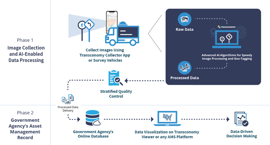
Transconomy has the power to perform this critical asset management function in a very effective way. Utilizing state-of-the-art Machine Learning (ML) algorithms, Transconomy can review the images, pick out the assets of interest in the images along with their location, and create a visualization of the assets at pennies per asset. The workflow and complete ecosystem are captured in the images below:
Traffic Signs and Roadway Elements Detection
As an example, Transconomy can detect and classify signs using the Federal Highway Administration’s (FHWA) Manual on Uniform Traffic Control Devices (MUTCD) and can detect other roadway furniture according to the FHWA’s Manual on Model Inventory of Roadway Elements (MIRE) system. This data can be used for many purposes besides asset management including safety studies, lighting sufficiency studies, number of lanes, lane-making adequacy, complete streets planning, and more. The uses for data-driven decision-making are almost endless!
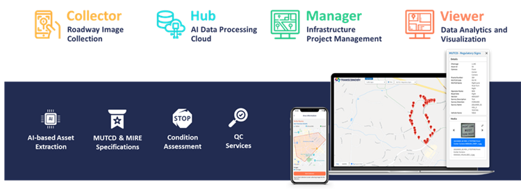
This asset extraction is done using an ecosystem of products including those that are shown below:
Sign Inventory and Condition Case Study
As a demonstration of the power of the Transconomy ecosystem, we partnered with a well-known professional services firm to create a traffic sign inventory and sign condition database for a city client. Staff at the consultant collected about 100 lane miles of the street imagery. Nearly 50,000 images were then uploaded to the Transconomy Hub, where the Transconomy AI algorithm was executed. These raw images were automatically processed to identify assets, remove duplicate assets in consecutive images, and geo-tag asset locations on a map. The software also provided the GIS-based asset inventory in Shapefiles (SHP) for use in ESRI applications and Keyhole Markup Language (KML) files for Google applications. This street imagery can be exploited for many other use cases as well now that it is collected. Read the full case study here.
Contact Transconomy if you have already collected right-of-way imagery or want us to collect it for you using our smartphone app – Transconomy Collector – and are looking for additional use cases for the information. If you would like more information concerning Transconomy, feel free to surf our website.