TRANSCONOMY LENS

Conversational AI for Transportation Asset Data

Turn your roadway asset data into instant answers with AI-powered natural language querying. Simply ask questions in plain English and get clear text, maps, and charts you can use right away, no technical skills required.

TRANSCONOMY LENS

Ask, discover and decide
with confidence

Unlock the power of your geospatial transportation asset data with Transconomy Lens, a premium extension to the Transconomy Roadmap platform. Designed for today’s decision-makers, this AI-powered solution lets you query your Transconomy provided GIS data in plain English and instantly generate actionable insights - no technical skills required.

Transconomy Lens Thumbnail
Group 4944
YOUR DATA, NOW CONVERSATIONAL

Ask questions in plain English, get instant answers

Lens transforms the way you interact with your asset data. Simply type or speak your question. In seconds, Lens delivers answers as clear text, interactive maps, or charts, ready to share with your team or stakeholders.

element
YOUR DATA, NOW CONVERSATIONAL

Ask questions in plain English, get instant answers

Lens transforms the way you interact with your asset data. Simply type or speak your question.
In seconds, Lens delivers answers as clear text, interactive maps, or charts, ready to share with your team or stakeholders.

Q

How many miles of line striping does the city have?

Q

Which intersections are missing crosswalks?

Q

Where are stop signs rated in poor condition?

Group 4945
INTEGRATION, WITHOUT DISRUPTION

Seamlessly fits into your existing workflows

Built on the robust Transconomy Roadmap ecosystem, Lens integrates directly into your existing workflows, delivering:

  • AI-powered querying for instant answers
  • Interactive maps & reports for deeper exploration
  • Downloadable outputs for transparency and collaboration
  • Comprehensive lifecycle support from planning and data collection to advanced analytics and reporting.
element
Group 4943
ASSET EXPLORATION, MADE INTERACTIVE

Visualize, filter, and navigate your assets with ease

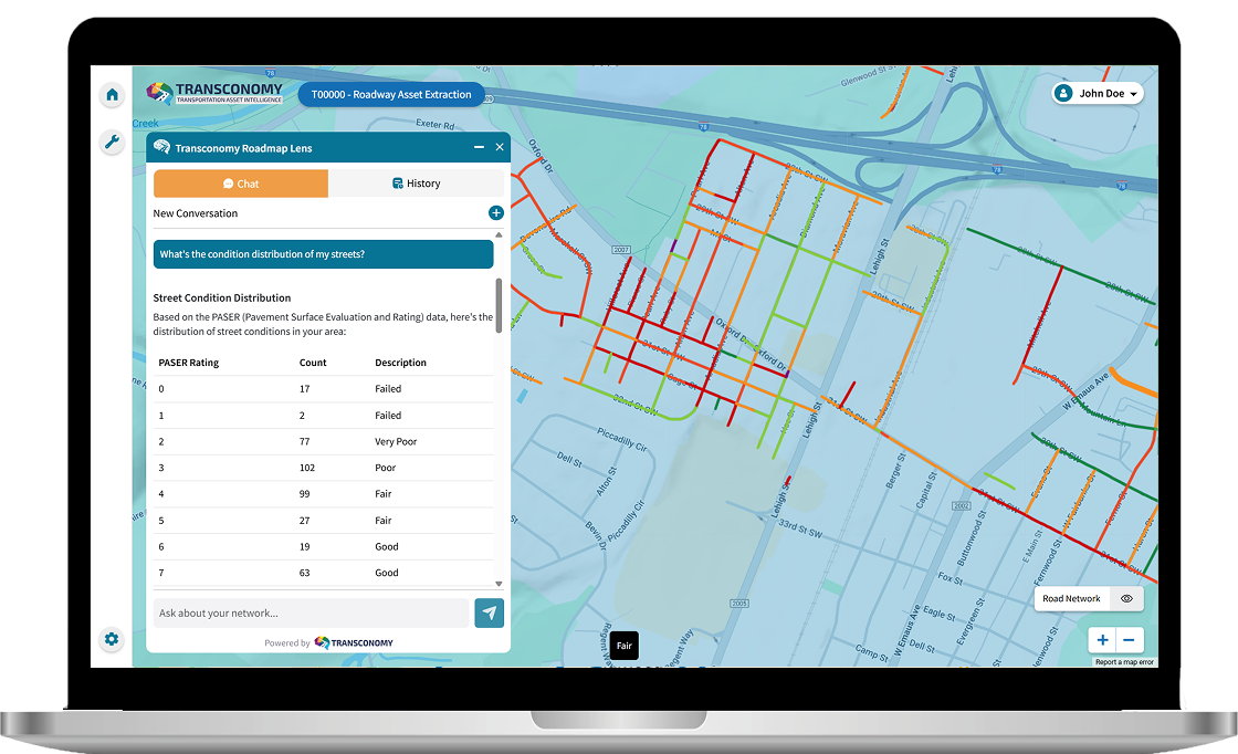
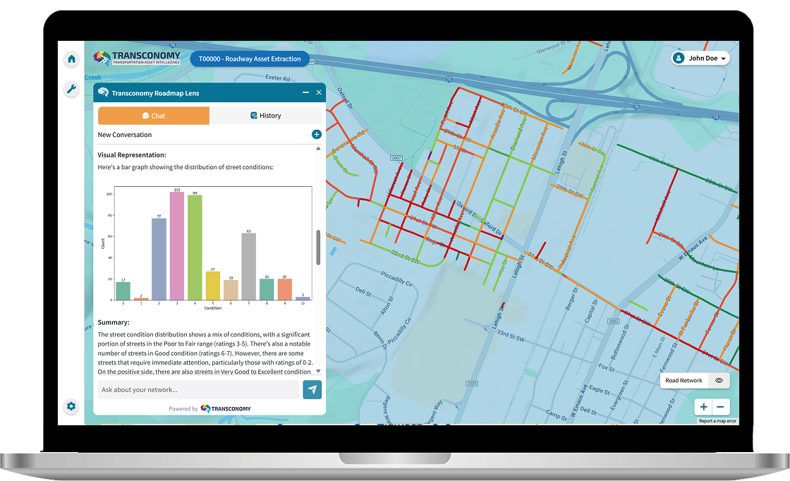
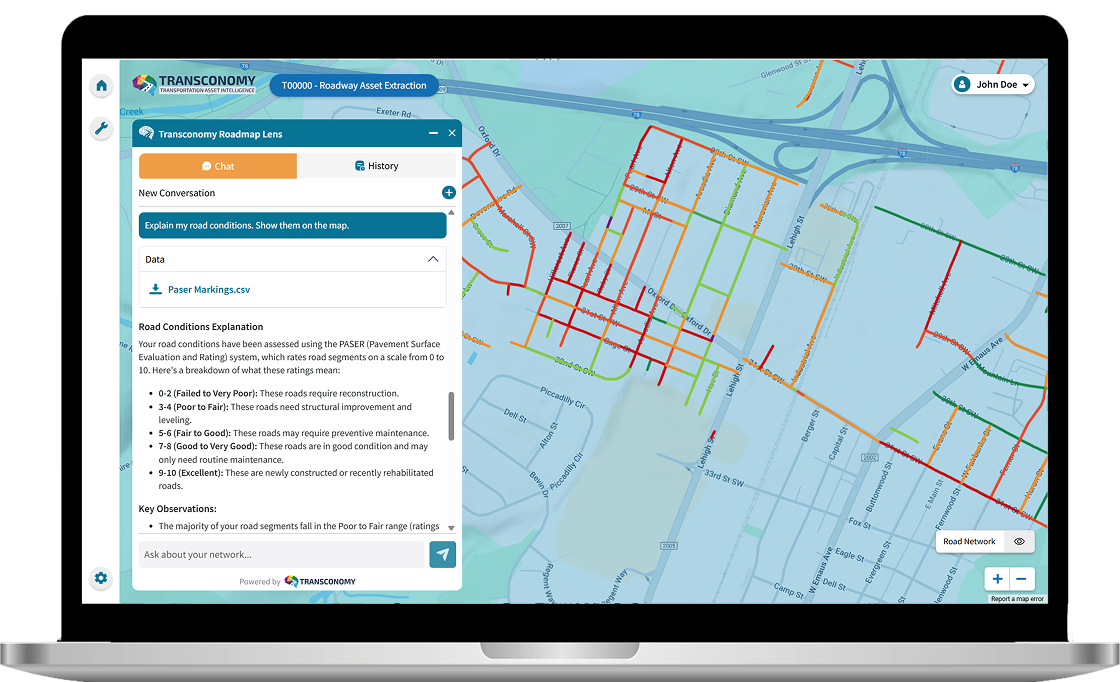
Seamlessly explore your infrastructure at every scale—citywide, along specific corridors, or down to individual assets. Navigate visually through interactive GIS maps or use the built-in chat to filter by location, asset type, or status.

Get instant, easy-to-read summaries of:

  • Infrastructure condition and performance
  • Maintenance hotspots
  • Asset costs and investment backlogs

Go deeper into the details or share results with colleagues and stakeholders in just a few clicks. All maps, reports, and insights can be exported directly into your existing workflows, ensuring transparency and coordinated action across your organization.

element
Group 4946
DECISIONS, BACKED BY CONFIDENCE

Turn insights into smarter, faster actions

  • Identify compliance issues and safety gaps.
  • Evaluate asset conditions and investment backlogs.
  • Estimate replacement or rehabilitation costs.
  • Make smarter, faster, more confident decisions.


element

Don’t be data rich but information poor