Concrete Asset Inventory for the City Of Englewood, Colorado
Scope: Transconomy collaborated with A.G. Wassenaar, Inc. (AGW), a consulting engineering, geotechnical, environmental, and pavement management services firm, to provide a comprehensive concrete asset inventory for the City of Englewood, Colorado.
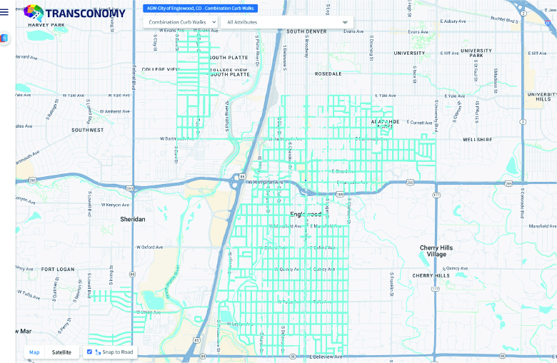
High-definition imagery was collected by AGW on 122 centerline miles of the City’s road network as part of their pavement condition assessment. In addition to the PCI survey on roadways, the City required an inventory of concrete assets for use in their enterprise GIS and Asset Management program. Assets to be collected were:
| Asset Type | Asset Features |
|---|---|
| Detached Sidewalk | Asset ID, GPS Location, Length, Width, Street Name, Cross Streets (Ahead and Behind) |
| Combination Curb Walks | Asset ID, GPS Location, Length, Street Name, Cross Streets (Ahead and Behind) |
| ADA Ramps | Asset ID, GPS Location, Length and Width of Concrete Segment, Street Name, Cross Street (Ahead and Behind) |
| Vertical Curb & Gutter | Asset ID, GPS Location, Type (Attached/Detached), Length, Street Name, Cross Streets (Ahead and Behind) |
| Chase Drains | Asset ID, GPS Location, Street Name, Cross Streets (Ahead and Behind) |
| Cross Pans | Asset ID, GPS Location, Length, Street Name, Cross Street (Ahead and Behind) |
| Alley Entry Pans | Asset ID, GPS Location, Length, Street Name, Cross Streets (Ahead and Behind) |
Process: The geo-coded images were uploaded to Transconomy Roadmap.
Images were processed through Transconomy’s AI models, which detected, classified, and assigned the required data for each asset class. In addition, high-resolution aerial imagery was utilized along with an AI model to provide accurate geometry measurements. The extracted images and data were quality-controlled through Transconomy’s stratified, Human-in-the-Loop quality assurance process.
Results: Transconomy successfully extracted and delivered a complete inventory of the requested concrete assets.
The finalized data was delivered in Transconomy Viewer, which allowed for interactive, web-based data and image viewing. The dataset also maintained the City’s database schema, ensuring a smooth integration into the City’s Enterprise GIS and Enterprise Asset Management (EAM) systems. Critically, the data maintained existing Asset IDs while updating the current inventory information for previously identified assets, while providing new unique Asset IDs for newly inventoried assets. Furthermore, the updated dataset enhanced the City’s ability to make data-driven decisions and efficiently manage resources.
Benefits: For the City of Englewood, this project allowed them to maintain their active Pavement Management Program while leveraging AGW’s field data collection efforts and collected imagery to update the inventory of important features in their Concrete Feature Inventory database.
These features are now current and integrated into the City’s Enterprise GIS and EAM, supporting the City’s efforts in street maintenance prioritization. The City was also able to further define asset properties and relationships for the City’s Concrete Utility Program. Further analysis of the collected sidewalk data was completed to identify opportunities for the placement of Detectable Warnings on sidewalks where both pedestrian and vehicular traffic are at higher volumes, allowing the City to improve safety for citizens. This initiative has set a new benchmark for accessibility improvements in urban planning.
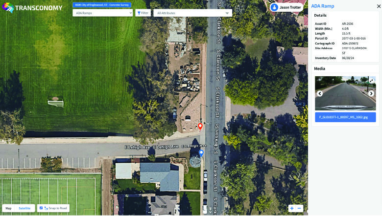
The interactive interface of Transconomy Viewer enhanced the usability of the data, empowering stakeholders to explore the concrete assets along with data and images for each feature. The fully integrated datasets support a data-driven approach to near-term maintenance planning and prioritization. Having all assets within a common EAM and GIS simplifies the ability to review the implications of maintenance or strategic investments and provides a clear understanding of the components of the City’s roadway and right-of-way.
The project highlights the opportunity to maximize the value of right-of-way image collection by extracting critical assets while updating pavement management data. Transconomy’s AI models extracted key assets for the City and delivered the data formatted for integration into the City’s GIS and EAM systems, fully integrating key assets to inform maintenance and planning, including enhanced safety for City stakeholders through asset data analysis.